Pitt’s ULS Gets $200,000 to Continue Restoring Century-old CONSOL Mining Maps
A public/private pledge of $200,000 will help catalog and preserve a University of Pittsburgh collection of area mining maps that date back to the 1850s. The collaborative effort, called the CONSOL Energy Mine Map Preservation Project, is designed to increase access to these valuable documents, which could impact mining safety, operations, land reclamation, development, and research.
The commitment represents a partnership in funding with CONSOL Energy Inc., the Pennsylvania Department of Environmental Protection (PA-DEP), and the U.S. Department of the Interior Office of Surface Mining (OSM). CONSOL Energy has pledged $100,000; PA-DEP, $75,000; and OSM, $25,000.
The important collaboration at Pitt was celebrated Jan. 15 at the University Library System (ULS) Preservation Department in Point Breeze. Coal mining executives, Pitt dignitaries, librarians, archivists, and news reporters gathered to hear about and witness first-hand the CONSOL Energy Mine Map Preservation Project.
“There’s not a library in the United States better positioned to take on this project,” said Rush Miller, Hillman University Librarian ULS director, adding that the ULS is a national leader in the effort to digitize materials.
In 2004, CONSOL Energy donated a vast collection of mining maps, records, survey books, photographs, and published materials to the ULS. The bulk of it dates from the 1890s through the first half of the 20th century. There are more than 8,000 individual map sheets, the earliest one from 1854, as well as coal mine artifacts and other historical items.
The collaborative project involves cleaning and restoring the color-coded maps, then transferring them to the OSM in Greentree for digitization. Pitt archivists will create information about each map that then will be entered into a database—the Pennsylvania Historical Underground Mine Maps Inventory System (PHUMMIS). That part of the project is managed by PA-DEP. The original maps are then taken back to Pitt’s Archives Service Center where they are kept in a climate-controlled environment.
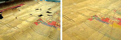
Visitors were given a tour of the facility to watch paper conservator Amy Baker and her team work on the huge maps. Some of the canvases can measure as large as 30 feet by 5 feet and have been rolled up for more than a century. They must first be placed into a humidity dome so the paper fibers can absorb moisture, thus preventing cracking. Once the map is able to be unrolled, it is placed between wool felt and polyester webbing to dry. Then the conservators work to remove coal dust and other grime from the map’s surface. Any rips or tears are carefully mended.
The archivists regularly field calls from people asking for a digital print of a mine map. Callers could range from a developer wanting to build a new property to a homeowner seeking the source of water in his basement.
“This project is important not only in terms of historical and artistic value, but also in terms of determining the location of these underground workings for the sage development of numerous surface structures or adjacent mining operations,” said Peter Lilly, president of CONSOL Energy-Coal Group.
“These historic documents can help strengthen Pennsylvania’s mine safety and mine subsidence programs, as well as help municipal planners and developers locate mine voids and choose stable sites for new economic development opportunities,” said PA-DEP Acting-secretary John Hanger.
Thomas Shope, director of OSM’s Appalachian Region, says OSM has provided more than $1 million to 32 underground mine mapping projects in 15 coalfield states since 2005.
“In all our projects, we partner with state, industry and/or academia to fulfill our goal of acquiring, preserving, archiving, and making abandoned underground coal mine maps generally available before they are lost forever,” he said.
As for Baker, she says she “loves getting up for work in the morning.” She took a special interest in restoring the large map of the Black Diamond mine near Donora, Pa.
“It’s where my grandfather worked,” she smiled.
Additional information on the CONSOL Energy Mine Map Preservation Project is available at www.pitt.edu/~aeb59/index.html.
Other Stories From This Issue
On the Freedom Road

Follow a group of Pitt students on the Returning to the Roots of Civil Rights bus tour, a nine-day, 2,300-mile journey crisscrossing five states.
Day 1: The Awakening
Day 2: Deep Impressions
Day 3: Music, Montgomery, and More
Day 4: Looking Back, Looking Forward
Day 5: Learning to Remember
Day 6: The Mountaintop
Day 7: Slavery and Beyond
Day 8: Lessons to Bring Home
Day 9: Final Lessons